MetroPCS and Virtual Earth (Cell Coverage Map)
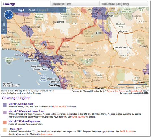
 Last August, I posted an entry about MetroPCS and store locator leveraging Microsoft Virtual Earth to find locations for products and services. Well, MetroPCS has extended their use of Virtual Earth to their coverage map application so you can see where their cell coverage is for their services. When you have a Virtual Earth contract it is an enterprise wide contract, so its in your best interest to use it where you can across your company. Reduce your costs by eliminating unnecessary duplication of technologies! If you don’t think Virtual Earth will support your needs, you should read more of my posts. For now, check out this coverage map showing the different types of coverage available from MetroPCS.
MetroPCS is using a raster overlay to highlight the different types of coverage you can expect with their service. Blue – MetroPCS Home Area; Purple – Extended Home Area; Red – Future Expansion; and Orange – Travel Talk (aka Roaming). Now, if they choose to do so, they could also add vector data to this map, as well. Tower locations, store locations, etc. They also leverage our geocoding capabilities by address, intersection and place name. All good stuff. The work was done in conjunction with one of our partners, SpatialPoint. And, hey, check out the road to Vegas from LA – coming soon. They know where they’re needed. Thus, if you need to drive to a company junket to blow some cash you certainly can stay connected while you do so.
CP
