Maps.ca (Yellow Pages Canada) and Virtual Earth
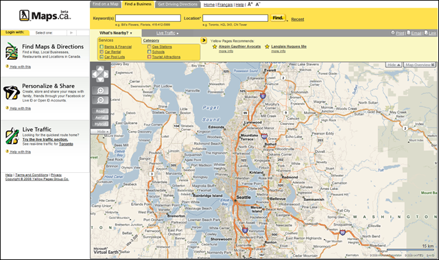
 Yellow Pages in Canada just got a whole lot more interesting. Maps.ca (or Mappes.ca for you French Canadians) has launched the beta of their new YP portal featuring Microsoft Virtual Earth dead center. This site is so jam-packed with features and content that I didn't know where to begin. Well, they dropped me on the search page which is logically a good place to start when I want to find stuff in the Yellow Page directory. Notice how that although this is Maps.ca ("Maps" being maps and "ca" being Canada) it still centered my map on Seattle? A little reverse IP lookup - a nice start.
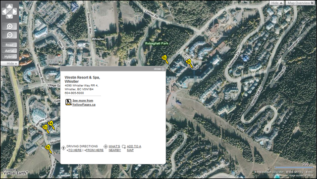
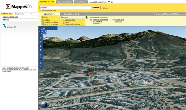
I searched for hotels in Whistler, BC and got a plethora of results. If you've never been to Whistler, you have to go. Around Christmas it's like the North Pole. And, if you drive it from Seattle you can tell the kiddies that you ARE going to the North Pole. Notice the custom pushpins - blue for the location (Whistler), yellow for YP listings and white, well, I couldn't figure out the white pins. I was thinking it was White Pages, but these were commercial entities, so IDK what they are. Maybe they'll share with us. Also, notice the custom EROs and the information inside them. Some of the popups are bigger (specifically the yellow ones) which I assume are meant for photos, but I couldn't get any photos to load, so the mystery continues! There are also links for driving directions, what's nearby (an additional search - sweetness) and "add to a map." We'll go over that in a bit.
There are 3 tabs at the top of the site. The default is "Find a Business" which is what I just talked about. "Find on a Map" will search for locations using the Virtual Earth AJAX Control's geocoding capabilities. So, input an address, place of interest, etc. and get results. The last tab is for getting driving directions which you can input an origin and destination and get directions. The site will also load our traffic feeds (native to Virtual Earth for those of you who have a license) - one line of code.
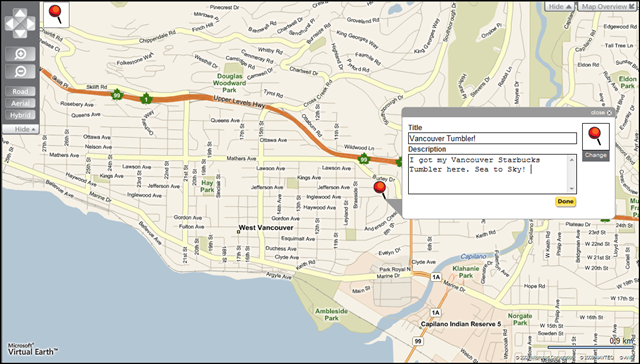
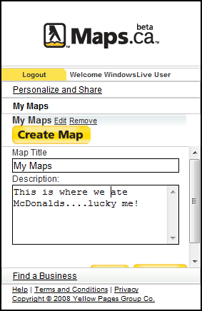 Okay, so now let's customize, shall we? Maps.ca/Mappes.ca will allow you to login with your Windows Live ID, Facebook ID or Open ID. This allows you to record stuff and save it for future reference. Once you login, you can choose "Create Map" which is basically your own little collection of points that you can come back to when you feel like it. You just click Create Map, then a red pin will appear with the map. Click the red pin and you'll see your mouse cursor change to cross hairs. You can zoom into where you want to place the pin using the middle mouse wheel (the wheel zooms, but clicking and drawing a box with the middle mouse wheel will let you zoom in super fast) or use the nav tools they provide to get in there. Place your pin, give it a title, give it a description and click done. You can keep doing this until you've got your set of pins just right, then your collection of pins is stored to your custom map and you can use them later, share them with friends or, if you login with Facebook, you can publish them to your Facebook. A nice feature for those who like to share their mapped locations.
I like this site's layout. If I change my search type, it doesn't interfere with my map - critical. I also like how low profile the ads are. Plus, I can hide almost anything! I love this. Give me more map! Hide the map overview; hide the ads and suggested searches; hide the navigation bar. Very nice! Take notes everyone, I see a lot of sites - the site looks real clean and operates well, but of course I have some feature requests (see below).
Oh and kudos for making driving directions easy to print. I was thinking the directions were a little constrained in the left hand tabs, but when I clicked print I got my directions and a map.
Some feature request:
- Search results should be dynamic with map movement. Once I perform my search I want it to refresh the results on the map if I pan or zoom the map.
- Route around traffic. Showing traffic is nice; but, show me a better way to get around the traffic. It's native in the control, so feel free to use it.
- Use Bird's Eye! We're spending a ton of money on this unique imagery that you get as a part of the control and you're not using it. Shame, shame.
- Remember what I'm searching for when I get driving directions. I was searching for hotels in Whistler. Then, I created a route from Toronto to Montreal. My hotel search got whacked. How about a corridor search for hotels along my route?
- Let me logout! I logged in with Windows Live ID, but I also have a Facebook ID. In order to logout I had to close the browser.
All in all a great site! I know, I have a lot of feedback, but the site is very user friendly and packed with stuff to do....I just want to do more. Oh and hey, the French site Mappes.ca supports 3D!
Ok, not really, I just like to hack around; but, the map control is localized for French so you can have a French dashboard (default navigation), French Driving Directions, French Geocoding (Les Etats-Unis) and with the latest release tiles rendered in French. C'est chic!
Go to Whistler - it's incredible. Use Maps.ca to find stuff to do while you're there.
CP