Studying Climate Change in Alaska
The Microsoft Environment Team published a case study called "Studying Climate Change With a SEAMONSTER" which leverages many Microsoft technologies including Microsoft Research personnel, but most importantly Virtual Earth. If you've ever seen The Day After Tomorrow, you might be reminded of the kind of catastrophes that could happen due to global warming. Hey, based on information from the Intergovernmental Panel on Climate Change, "If glaciers outside Antarctica or Greenland melt at an accelerated pace, many coastal areas could find themselves swamped. "
Okay, the movie was a bit of a stretch; good movie though.
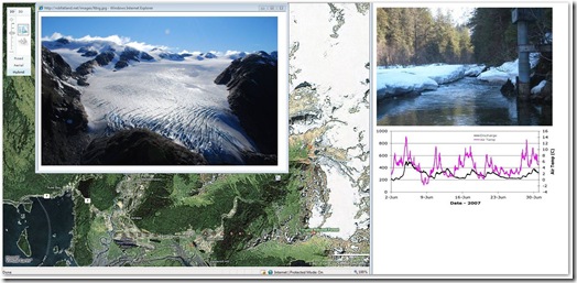
Rob Fatland, a research scientist with Colorado-based Vexcel Corp., a wholly-owned Microsoft subsidiary focusing on geospatial imaging and remote sensing technology is spending parts of three summers tromping around the surface of a vast ice field near the Alaskan city of Juneau. There, he and fellow researchers from the University of Alaska are working on a project colorfully dubbed SEAMONSTER, for Southeast Alaska Monitoring Network for Science, Telecommunications, Education and Research.
Well, as many of you know, Vexcel is the subsidiary where we get our UltraCam aerial photography and stereo pairs to create the 3D building models you see in Microsoft Virtual Earth 3D, as well as our own proprietary ortho photos. So, there's a natural synergy for this project to map out data gathered from different locations with photos atop of Virtual Earth. In fact, Rob Fatland has made use of Virtual Earth to help display data from SEAMONSTER in an easy-to-see way. He and his co-researchers also have worked to make the project easily accessible as a teaching tool for students. You can see the tool (fairly rudimentary at this point) on Rob's web site. This is a simple, but excellent, example of how Virtual Earth can be used as the interface for rendering biogeochemistry information for visualization and analysis.
CP