MSNBC Maps Midwest Floods with Virtual Earth
MSNBC published a Virtual Earth map highlighting points along the Mississippi River (and one in Michigan) where towns are getting flooded in the Midwest United States. Each point represents a city with flood issues such as Rock Island, Il and hovering over each city the popup provides you with (a) the current river level (near real time), (b) the forecasted maximum level the river reach in the respective city during this storm and (c) the record historical level and the date it was observed. If you can move your mouse fast enough, there are links to news stories and videos on some of the pushpins popups.
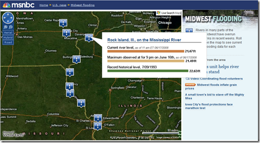
Most of the towns in Iowa and Illinois show that river levels are near or surpassing record levels set in the past. From what I saw on the news this morning, the towns in the southern states bordering the Mississippi River have somewhat of a river tidal wave coming their way and need to batten down the hatches as the river is gaining strength. Hold tight folks.
And after the storm passes, you can always do what Central Florida News 13 did - show the areas as they are today and use Virtual Earth to illustrate what they looked like before the storm. A good use of Virtual Earth imagery when dealing with insurance companies, plus it's free for consumer use on Live Search Maps.
CP