Getting Addresses Using Aerial Photos
I wrote a little mashup for Where 2.0 that shows some functionality I've always wanted and was just too lazy...I mean busy! to get it done. The idea is that if I ever wanted to know what the lat/lon of a specific location on a map is (since I write a few geo-apps) all I wanted to do was click on the map (or in this case an aerial photo). In Virtual Earth 6.1, I had to take it a step further and reverse geocode the lat/lon for an address. I got really greedy and wanted to show a Bird's Eye image. Well, here we go:
- Click on any location (or friend's / enemy's house)
- Provide me with the lat/lon
- Provide me with the address
- Provide me with a Bird's Eye Photo
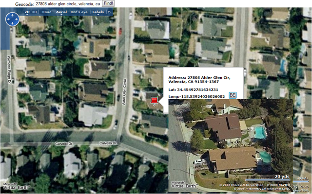
I have to warn you, the app isn't totally stable but it works pretty well. Click anywhere on the map and you'll get a pin. Hover over the pin and you'll get a popup with the closest address to that respective point on the map. There's a button in the popup which you can click and get a Bird's Eye image of that location. You'll need to move your mouse of the Bird's Eye photo so it stays and you can't navigate it, but I thought I'd at least get the code out there for others to help me perfect it. Also, I didn't put great coding practices out there so no try / catches or exception handling. Sorry - this is quick and dirty folks!
The code is documented below. I posted it the app up to my SkyDrive for those of you who don't code, but want to see the application in action.
<!DOCTYPE html PUBLIC "-//W3C//DTD XHTML 1.0 Transitional//EN" " https://www.w3.org/TR/xhtml1/DTD/xhtml1-transitional.dtd" >
<html>
<head>
<!-- saved from url=(0014)about:internet -->
<title>Clickable Address Finding</title>
<meta http-equiv="Content-Type" content="text/html; charset=utf-8">
<script type="text/javascript" src=" https://dev.virtualearth.net/mapcontrol/mapcontrol.ashx?v=6.1" ></script>
<script type="text/javascript">
var map = null;
var locations = null;
var pixel = null;
var clickEvent = null;
var LL = null;
var BEMap = null;
function FindLocation()
{
map.Find(null, txtGeocode.value);
}
function GetMap()
{
map = new VEMap('myMap');
map.LoadMap(new VELatLong(37.6028082592364, -122.37150549888612), 17, VEMapStyle.Hybrid);
map.AttachEvent("onclick", PixelClick);
}
function PixelClick(e)
{
var x = e.mapX;
var y = e.mapY;
pixel = new VEPixel(x, y);
LL = map.PixelToLatLong(pixel);
map.FindLocations(LL, GetResults);
}
function GetResults(locations)
{
var strOutput="Address: ";
if(locations)
{
for(var i=0;i<locations.length;i++)
{
strOutput+=locations[i].Name;
strOutput+="<br/><br/>Lat: " + LL.Latitude + "<br>Long:" + LL.Longitude;
var strBERequest = " <input type='button' value='BE' onclick='GetBEMap(LL);' size=10><br><div id='myBEMap'
style='position:fixed; width:400px; height:300px;'></div>";
var myPushpin = new VEShape(VEShapeType.Pushpin, LL);
strOutput+=strBERequest;
myPushpin.Title = strOutput;
myPushpin.SetDescription = strOutput;
map.AddShape(myPushpin);
}
}
else
{
strOutput+='No Result found.';
}
}
function GetBEMap(LatLong)
{
BEMap = new VEMap('myBEMap');
BEMap.LoadMap(new VELatLong(LatLong.Latitude, LatLong.Longitude), 19, VEMapStyle.BirdseyeHybrid);
BEMap.HideDashboard();
}
function ClearPins()
{
map.DeleteAllShapes();
}
</script>
</head>
<body onload="GetMap();">
<p>Geocode: <input type="text" name="txtGeocode" size=30><input type="button" value="Find!" onclick="FindLocation();">
<div id='myMap' style="position:relative; width:1000px; height:600px;"></div>
<br><input type="button" value="Clear Pins" onclick="ClearPins();"><br/>
</body>
</html>
Copy. Paste. Run.
For those of you who are going to ask, no you can't click a Bird's Eye photo in the map control and get the lat/lons. We don't expose lat/lons in Bird's Eye mode.
CP