Indiana Jones and The Kingdom of the Crystal Skull
The French MSN Entertainment team did a sweet mashup for the release of the new Indian Jones movie - Indiana Jones and The Kingdom of the Crystal Skull. The application highlights different scenes in the movie, specifically where they take place across the globe. Yes, it's in French since the movie debuted in France at the Cannes Film Festival.
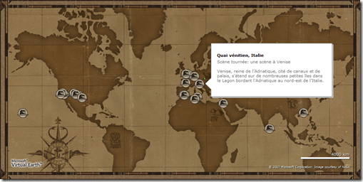
The application uses our raster overlay capabilities. You can take your own images or PDFs (such as this map) and layer them atop of Virtual Earth to give your maps a more custom look and feel.  There are a few different ways to overlay rasters atop of Virtual Earth - (a) you can "Build Your Own Tile Server" as documented in the MSDN Technical Article; (b) you can use Microsoft Map Cruncher; or, (c) you can use a third party such as Safe's FME which will allow you to convert vector data to Raster format and store it in SQL Server on the fly. Fun stuff when you start talking about Indiana Jones - check out the trailers here.
Plus, all of the vector information such as pushpins, line and polygons will still work with geo-accuracy. The application also highlights custom pushpins and information in the pop-ups when you hover over a pushpin. Pushpins in Virtual Earth can be any .gif you want - they chose to use Indy's hat. When you roll over the pin (or hat) you get additional contextual information about the respective point.
And, did you know that Live Search Maps now allows you to create and share a collection of rasters? You still have to find a place to store the tiles once they are created (I use Amazon S3 service), but now you don't have to be a developer to show people your cool custom maps. And, it works natively in 3D (CTRL + 3).
CP