Visualizing Broadcast Areas in Virtual Earth
Our Microsoft Certified Partners SpatialPoint are at it again. They've published a new visualization tool for viewing radio broadcast signal coverage areas by station at FollowTheGame.com. The theme for the application is football, so you can stay tuned to the big game(s) while you're driving state to state. You'll know what radio station to tune into depending on where you are; however, you can imaging how useful this might be for radio stations in general - and what a great marketing tool this would be for Satellite radio (I'm a Sirius subscriber myself).
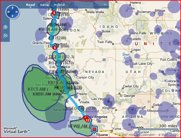
I performed a search from Bellevue (home) to San Diego (hometown) to "pat" the Chargers on the back for a game well played - Hey! They made it interesting!. The site is a bit rough - you need to click "Find" and "Directions" in order to see both directions and the signal coverage areas and the radio stations who are transmitting them, but all in all this is a great illustration of the power and flexibility of the Virtual Earth platform. So, how did they do it? They're using raster overlays (perhaps generated from MapCruncher). The data comes from their own sources which get rasterized before being published.
I had published a similar post about signal strength on the MapPoint B2B Blog some time ago.
I've also included the press release from SpatialPoint below:
Chicago, IL – January 17, 2008 –SpatialPoint, a Microsoft Certified Partner, today announced the launch of FollowTheGame.com, to help people find radio stations that will be carrying the game on football’s biggest night, wherever they may be located. FollowTheGame.com uses Microsoft SQL Server 2008, Microsoft Virtual Earth, and SpatialPoint Atlas to allow users to enter a location where they will be for the game, or an origin and destination for a route on which they’ll be traveling, and get a map with a list of all of the AM and FM radio stations where they will be able to listen to the game.
FollowTheGame.com is a free service. Users simply need to go to the web site and enter a location where they will be for the game or the origin and destination for a route on which they will be traveling. The service then geocodes the location, providing a latitude and longitude coordinate, and determines which stations carry the game at that location. For listeners that will be traveling, the system generates a route, and returns a list of radio stations that can be tuned into along the route. Users can be sure that they will be able to catch every minute of the action.
“FollowTheGame.com makes it easy for users to find a radio station that they can tune into to hear the big game.” said Alex Machinis, SpatialPoint’s President and CEO. “We are excited to bring this free service to the public, while demonstrating a real-world use of our technology. This application’s functionality is something that could be useful for anyone who is syndicating radio content.” he added.
The site uses SpatialPoint’s Atlas technology which allows visualization of even the most complex datasets on top of the Virtual Earth Platform. In this case, the radio stations coverage polygons, as registered with the FCC (Federal Communications Commission), are displayed by Atlas. Atlas is currently used by leaders in wireless, insurance, and hospitality to visualize coverage areas, perform risk analysis, and display franchise territories.
“FollowTheGame.com is a great example of what’s possible using the new spatial enhancements included with SQL Server 2008,” said Kim Saunders, senior director of SQL Server marketing at Microsoft Corp. “SpatialPoint’s use of spatial technologies as part of this service demonstrates how this technology can be used to solve customers’ real-world business problems.”
To find your Big Game radio stations, go to www.followthegame.com.
CP