Showing GPS Altitude, Speed, and Heading on Windows Mobile
Small update from yesterday's post - a screen shot to show Speed (knots I think) and Heading (360 degree based, Zero is north). This lat/long is at MaxTrain. Last night's post was done from my hotel. Interestingly, I'm am a little higher here than at the hotel (319 ft. above sea level, versus 231 as seen in yesterday's screen shot).
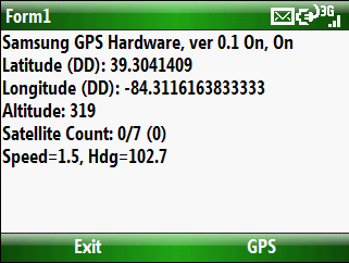
[Update: 6-26-2008] Confirmed that this speed is indeed "knots". Found on this NOAA site the conversion forumula: MPH = knots * 1.1507794. Knots is returned from the API as a float.